
Tropical storm Hernan weakens slightly as it continues to move parallel to the coast of southwestern Mexico. Location 15:00 hr La Paz / 21:00 UTC about 120 km (75 mi) SW of Cabo Corrientes Mexico and about 510 km (315 mi) SE of the southern tip of Baja California maximum sustained winds...65 km/h (40 mph). On the forecast track, the center of Hernan, along with the strongest winds and heaviest rains, is expected to remain just offshore of the southwestern coast of Mexico.
 with higher gusts.
Slow weakening is forecast over the next couple of days and Hernan
is expected to degenerate into a remnant low late this weekend.
Tropical-storm-force winds extend outward up to 105 miles (165 km)
from the center.")
For today,Thursday, 27. August 2020 expectations at La Paz, BCS area are: partly cloudy, high 37C, winds SW at 15 to 25 km/h.
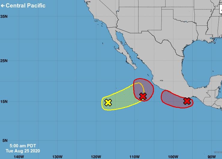
Tropical Storm HERNAN formed in the Eastern Pacific on 26 August and is moving north, along the Mexican western coast. On 27 August at 3.00 UTC its center was approximately 170 km south-west of Manzanillo (Colima State, central-western Mexico), about 625 kilometer SE of southern tip of Baja peninsula with maximum sustained winds of 65 km/h.

Today sunny to partly cloudy, peak temperatures again around 37C. Winds WSW at 15 to 25 km/h.
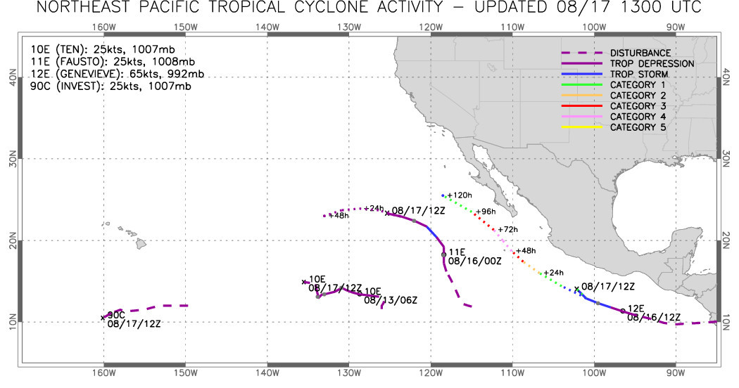
Tropical Depression Thirteen-E forms offshore the coast of southwestern Mexico. At moment (Wednesday 26.August 2020 / 04:30 hr) the location is about 340 km (210 mi) SSW of Cabo Corrientes Mexico and about 685 km (425 mi) SSE of the southern tip of Baja California.
https://blog.baja-weather.com/post/627508860727508992/26august2020

Today, 25th August 2020, we can expect sunny weather, peak temperature 36C. Winds W at 10 to 15 km/h.
There are several low pressure systems out in Pacific "brewing". While some may head our direction it's to early to make more detailed predictions.
Image/graphic credits NOAA
Baja Weather with a wider view. GeoColor - True Color daytime - 24 Aug 2020 - 1530 UTC. 4 hour loop - 24 images animated with our #Baja #peninsula good in sight.
Today's forecast not much different as the past days: Sunshine and clouds mixed, peak temperatures 37C. Winds N at 10 to 15 km/h.
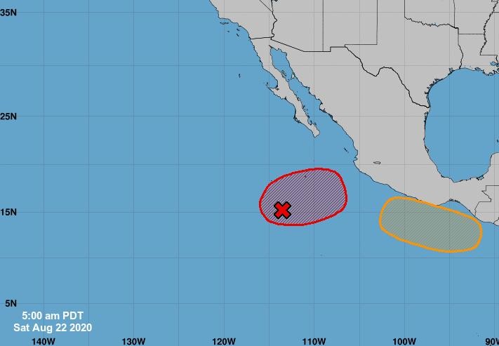
Today, Saturday 22. August 2020, plenty of sunshine, high temperature near 35C, winds NW at 10 to 15 km/h.
There are 2 systems out in the Pacific down south. So far nothing for us to be concernd - www.baja-weather.com will keep an eye on that for you!
On the forecast track, the center of #Genevieve will move farther away from the Baja California peninsula. Maximum sustained winds are near 50 mph (85 km/h) with higher gusts. Continued weakening is expected, and Genevieve is forecast to become a tropical depression by tonight, and degenerate into a remnant low by early Saturday morning.
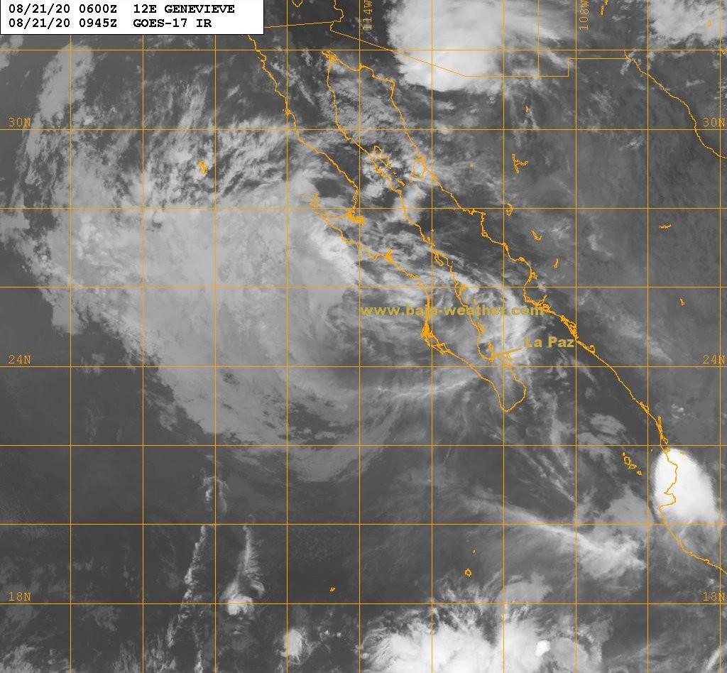
Hurricane-force gusts and heavy rainfall continue over southern Baja California Sur according to the last NOOA.
However, at 04:35 hr in La Paz, #Fidepaz area are barely any stronger wind gusts and zero rainfall.
Genevieve is moving toward the north-northwest near 7 mph (11 km/h).
A turn toward the northwest is expected later this morning, with that motion continuing through Saturday. #LaPazBCS #BajaSur #BCS
, the center of Hurricane Genevieve was 70 km (40 mi) SW of the southern tip of Baja California and about 320 km (200 mi) SE of Cabo San Lazaro, Mexico")
Hurricane #Genevieve jogs a little closer to Baja California Sur tropical-storm-force winds and heavy rainfall spreading slowly northward over southern #BCS
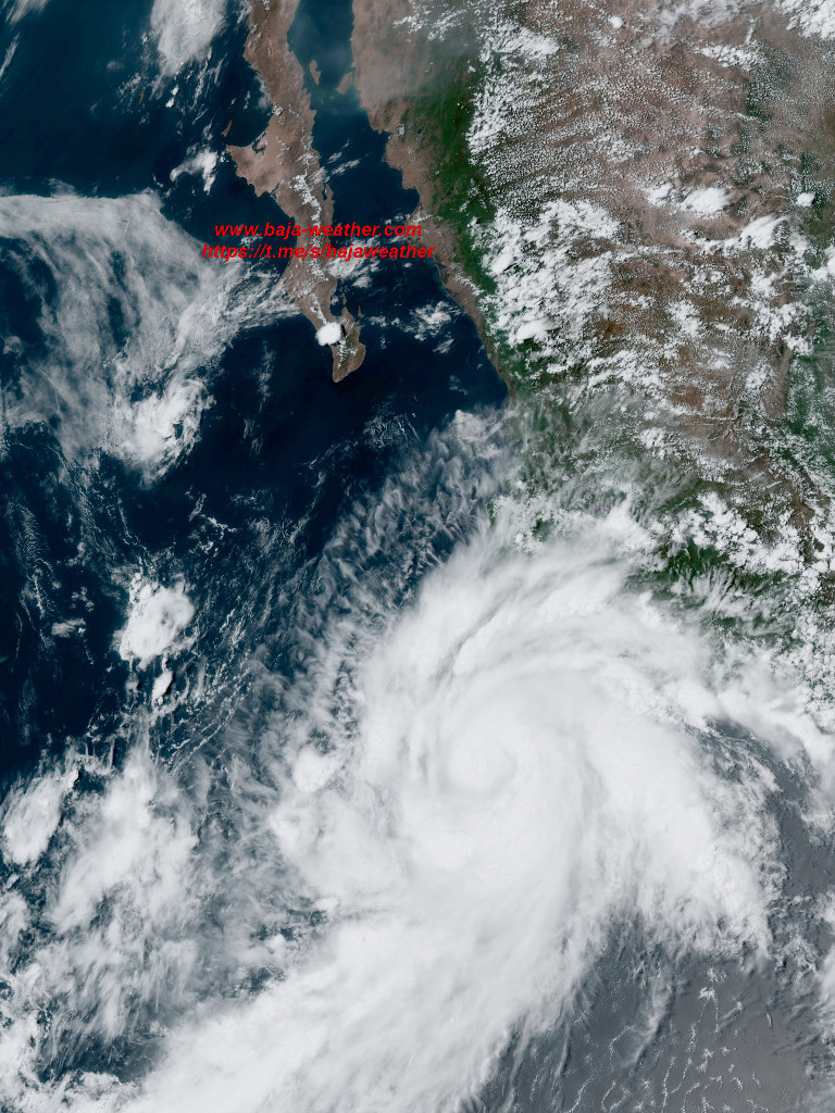
Impressive satellite footage from the hurricane 11:40hr satellite pass. 185 km of the southern Baja tip with 185 km/h winds!! Genevieve is expected to produce rainfall amounts of 3 to
6 inches with isolated totals of 10 inches across portions of far
southern Baja California Sur.


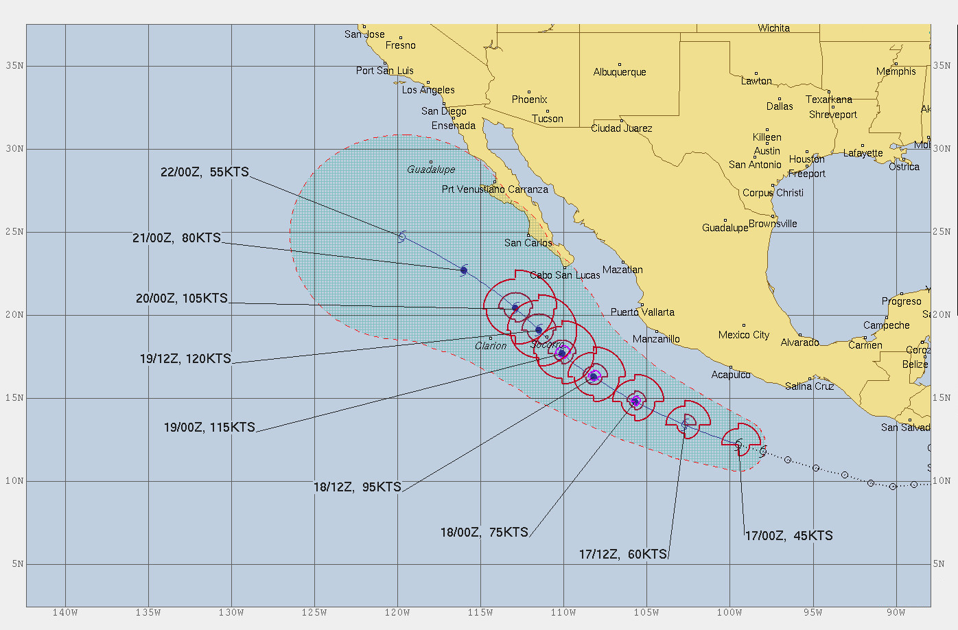
Hurricane Genevieve, a Category 3 storm is expected to pass near the southern portion of the peninsula on Wednesday night and Thursday. The center said Genevieve had maximum sustained winds of 115 mph (185 kph) Wednesday morning and was centered about 160 miles (260 kilometers) south of the southern tip of the Baja peninsula.

At 18:00 hr MDT (00:00 UTC), the eye of Hurricane Genevieve was located near latitude 19.0 North longitude 108.8 West, about 450km (280 mi) SSE of the southern tip of the Baja California, maximum sustained winds 205 km/h (125 mph)
This general motion is expected to continue with a decrease in forward speed through Thursday. On the forecast track, the center of Genevieve is forecast to move near but southwest of the southern portion of the Baja California peninsula on Wednesday night + Thursday.

Hurricane Genevieve - NOAA advisory #10 - The government of Mexico has extended the Tropical Storm Warning northward along the west coast of the Baja California peninsula from Todos Santos to Puerto Cortes and has extended the Tropical Storm Watch northward from Santa Fe to Cabo San Lazaro
The center of the hurricane is
then forecast to move to the southwest of the southern portion of the Baja California peninsula on Wednesday night and Thursday.
 with higher
gusts. Genevieve is a category 4 hurricane on the Saffir-Simpson
Hurricane Wind Scale. Genevieve should hold its intensity or
strengthen a little through Wednesday, but steady weakening is
expected after that.")
On the forecast track, the center of
Genevieve is expected to move parallel to but well offshore the coast of southwestern Mexico today.
The center of the hurricane is then forecast to move to the southwest of the southern portion of the Baja California peninsula on Wednesday night and Thursday.
https://blog.baja-weather.com/post/626809100540461056/18aug2020

Genevieve is forecast to become a major hurricane Tuesday. But it is not expected to make landfall, possibly passing near the tip of Baja California Sur on Wednesday night and Thursday.

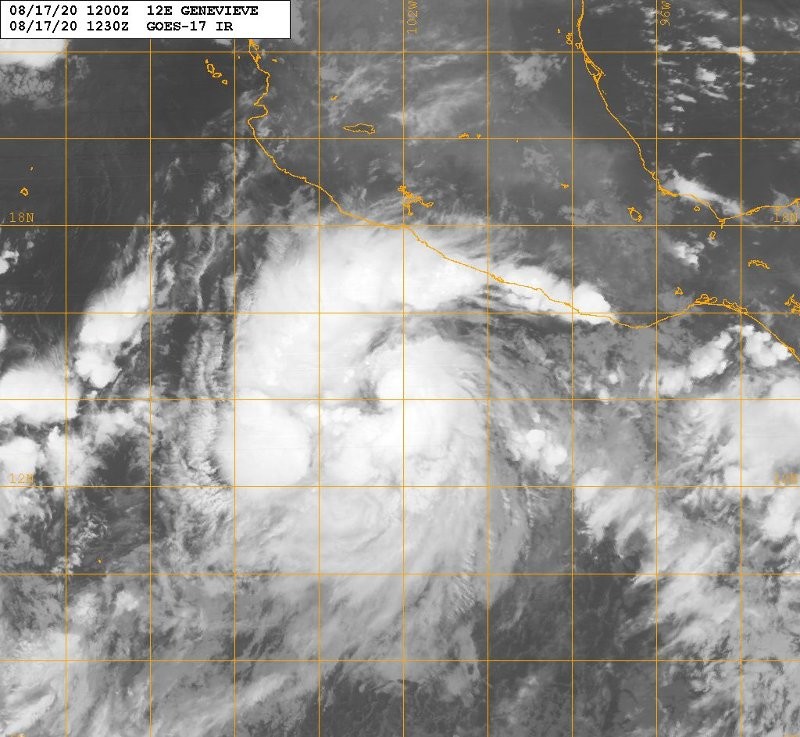
17 Aug 2020 - 21:26 UTC / 15:26hr GOES-East satellite pass, still plenty of cloud free spots.
https://www.facebook.com/BajaWeather/posts/3564024113607972
At 04:00 hr CDT, the center of Tropical Storm Genevieve was located about 445km (275 mi) SSW of Acapulco Mexico and about 490km (305 mi) S of Zihuatanejo Mexico maximum sustained winds 100 km/h present movement WNW or 290 degrees at 30 km/h.
Interests in the southern Baja California peninsula should monitor the progress of Genevieve.
Rapid strengthening is anticipated during the next couple of days, and Genevieve is forecast to become a hurricane later today and a major hurricane by Tuesday.
Today, Friday, 14. August 202 sun and clouds mixed,
peak temperatures 36C, winds SSW at 10 to 15 km/h.
Sunrise 06:57hr - Sunset: 19:56hr

Advisories on Tropical Depression Ten-E, located about 1500 miles west-southwest of the southern tip of the Baja California peninsula.
1.) A large area of disorganized showers and thunderstorms continues in association with a surface trough of low pressure located a few hundred miles west-southwest of Manzanillo, Mexico.
https://blog.baja-weather.com/post/626418395153399808/14august2020

13 Aug 2020 - 23:42 UTC
GOES-East satellite 17:42 hr La Paz time pass-over
#BajaWeather #WeatherForecast