Sunshine to start, then a few afternoon clouds. Peak temperatures expected 36C. Winds SW at 10 to 15 km/h.
Temperature wise this should be similar every day until Friday.
The predicted tide times today on Monday 16 August 2021 for La Paz are: first high tide at 16:04hr. Sunrise is at 06:56hr and sunset is at 19:53hr.


Where we stand regards of vaccinations and a few other nations to compare!

Expect the same as yesterday around same time today!
Partial cloudiness early, with scattered showers and thunderstorms during the afternoon.
High 32C. Winds NNE at 10 to 15 km/h. Chance of rain 40%.
Tropical storm Linda, 600km (375mi) SSW of Manzanillo strengthening quickly likely to become a hurricane tonight. Linda is moving toward the west near 12 mph (19 km/h). A westward to west-northwestward motion is expected during the next few days.
https://blog.baja-weather.com/post/659249994791108608/lindakevin
At the moment - 06:00hr, La Paz Fidepaz area - it is humid yet no rain as reported from other BCS locations.
The forecast predicts scattered thunderstorms during the morning becoming more widespread this afternoon.
High 31C. Winds SE at 15 to 25 km/h. Chance of rain 70%.
Predicted tide times on Tuesday 10 August 2021 for La Paz area: first low tide at 05:37hr, first high tide at 12:05hr, second low tide at 17:04hr, second high tide at 22:52hr.
Sunrise is at 06:54hr and sunset is at 19:58hr
Today mostly cloudy skies. High 34C. Winds SW at 10 to 15 km/h.
The predicted tide times today on Thursday 05 August 2021 for La Paz are: first low tide at 03:31hr, first high tide at 10:25hr, second low tide at 13:57hr, second high tide at 19:52hr
Sunrise is at 06:52hr and sunset is at 20:02hr
http://blog.baja-weather.com/
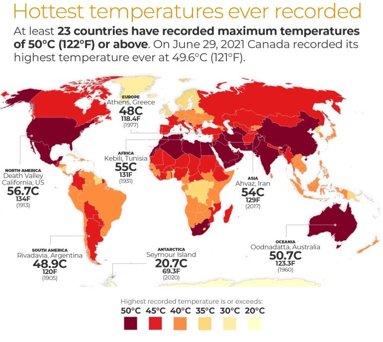
In 2019, Ripple and colleagues (2020) warned of untold suffering and declared a climate emergency together with more than 11,000 scientist signatories from 153 countries. They presented graphs of planetary vital signs indicating very troubling trends, along with little progress by humanity to address climate change.
https://bajaclima.com/climate

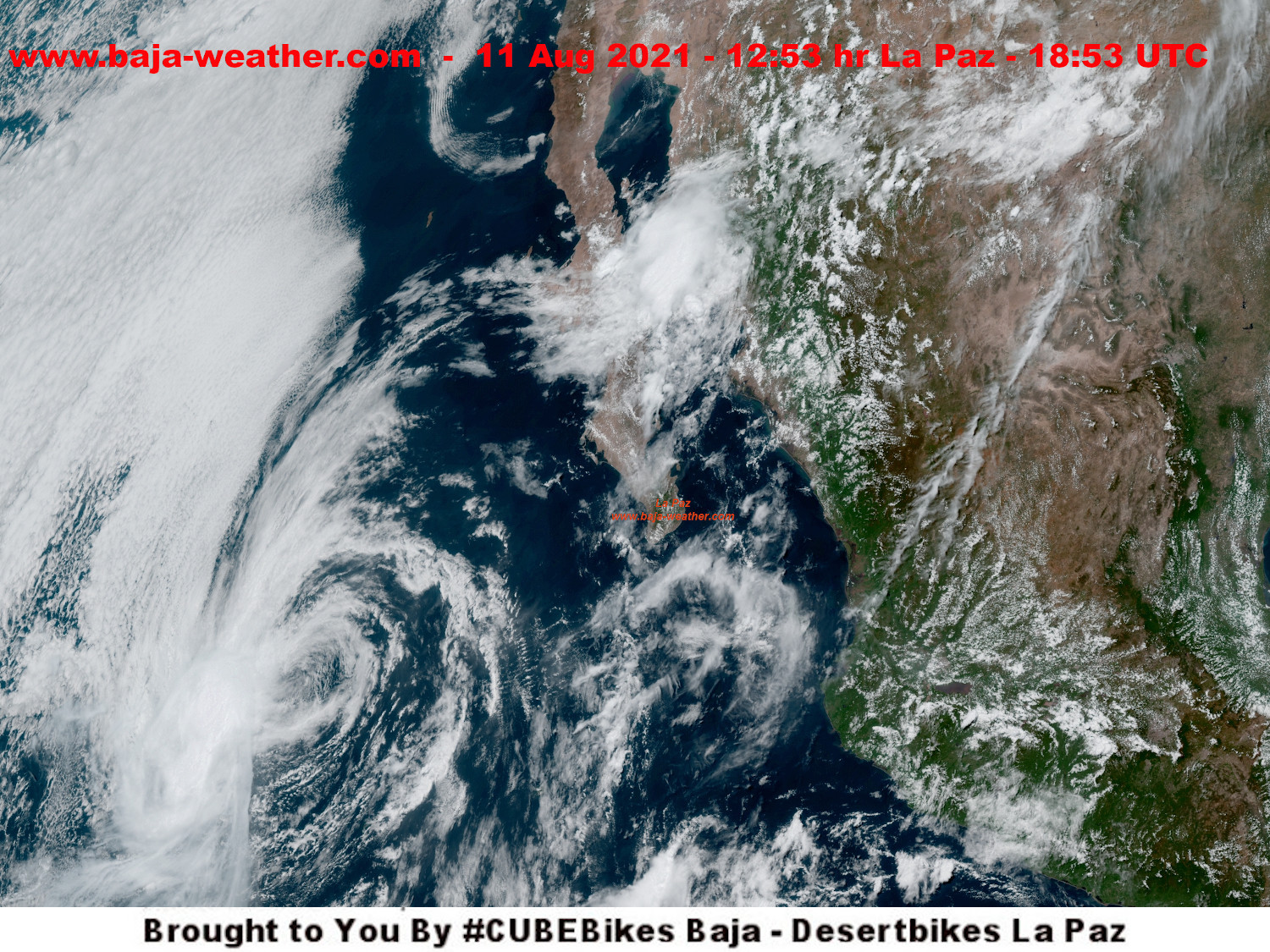
Baja Weather satelitte works - showing 2 systems out in Pacific moving away from Baja and as reference to gauge distance, La Paz
Tropical Storm Felicia located near latitude 16.1 North, longitude 133.4 West. Felicia is moving toward the west near 14 mph (22 km/h) and Tropical Depression Guillermo, 1100 km WSW of the southern tip of Baja California peninsula
https://ello.co/bajaweather


If you know that you're not getting better every day is painful and agony with no hope, it should be your human right to say "I've had enough."
It is unthinkable that people would rather have someone deny god's gift.
Forecast on Monday 19 July 2021 for La Paz and greater BCS area: It shows 28 °C this morning at 07:30hr and very humid at our weather station in Fidepaz area. Expect some clouds this morning which will give way to generally sunny skies for the afternoon, peak temperature 37 °C, winds WNW at 10 to 15 km/h.
2 systems far out turn AWAY from Baja peninsula.
Forecasts supported by #DesertBikes La Paz, BCS
http://blog.baja-weather.com/

Forecast coming week: mid 30′s°C at peak temperatures.
Please be good to yourself and stay hydrated! very important!!
Today sunshine and clouds mixed. High near 35°C. Winds WSW at 15 km/h to 25 km/h.
The predicted tide times today on Monday 12. July 2021 for La Paz are: first low tide at 06:05hr, first high tide at 13:06hr, second low tide at 16:57hr, second high tide at 22:48hr.
Sunrise is at 06:41hr and sunset is at 20:12hr.
https://blog.baja-weather.com/post/656503433288876032/12thjuly2021
The last seven years have been the warmest seven years on record, typifying the ongoing and dramatic warming trend. Whether one year is a record or not is not really that important – the important things are long-term trends.
https://bajaclima.com/hottest
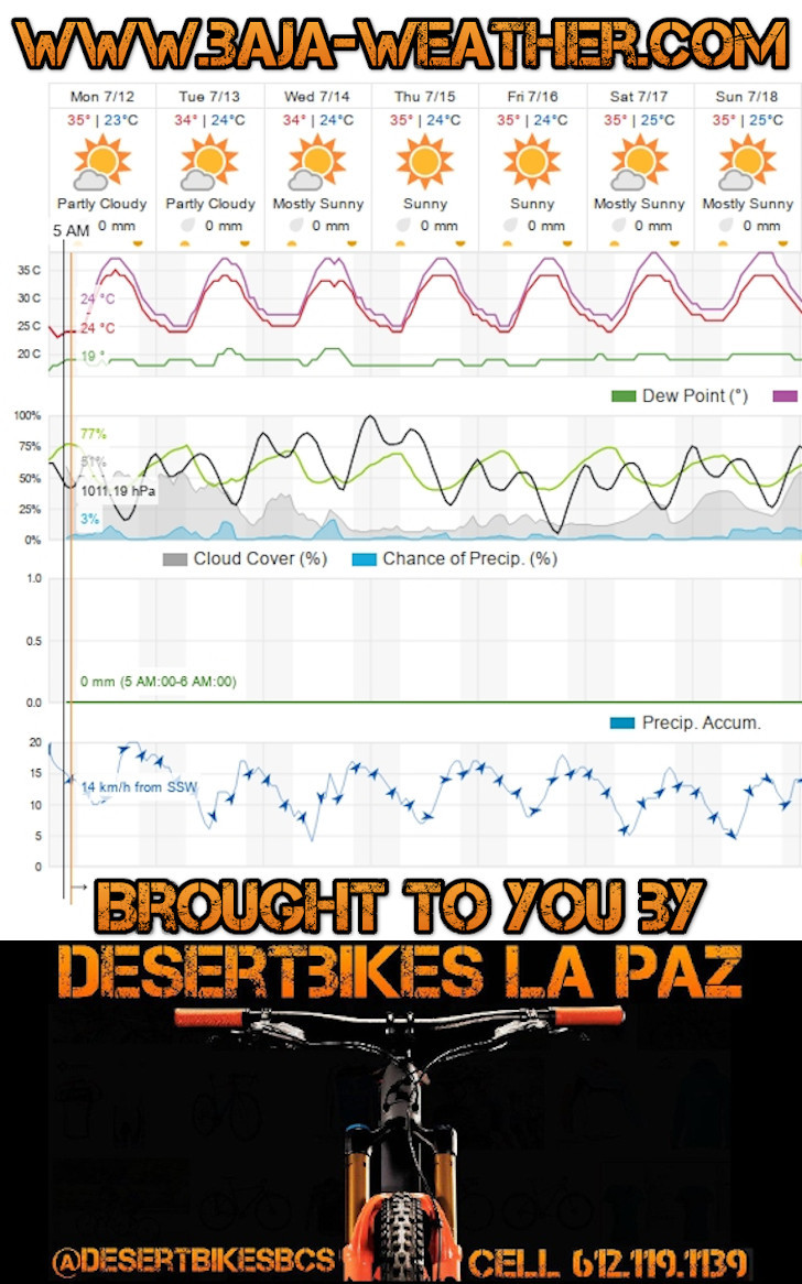
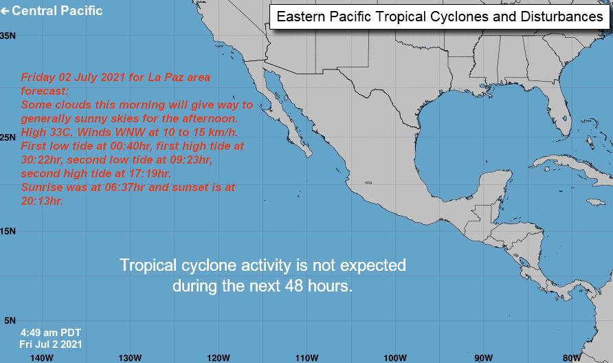
Friday 02 July 2021 for La Paz area forecast:
Some clouds this morning will give way to generally sunny skies for the afternoon. High 33C. Winds WNW at 10 to 15 km/h.
First low tide at 00:40hr, first high tide at 30:22hr, second low tide at 09:23hr, second high tide at 17:19hr.
Sunrise was at 06:37hr and sunset is at 20:13hr.
http://www.baja-weather.com
Wednesday 30 June 2021, 39% Precip. / 0.00 mm, showers early, then cloudy in the afternoon. High 27C. Winds SSW at 15 to 30 km/h. Chance of rain 40%.
First high tide at 00:04hr, first low tide at 08:11hr, second high tide at 16:04hr, second low tide at 21:17hr.
Sunrise was at 06:36hr and sunset is at 20:13hr
https://blog.baja-weather.com/post/655439409132470272/30thjune2021

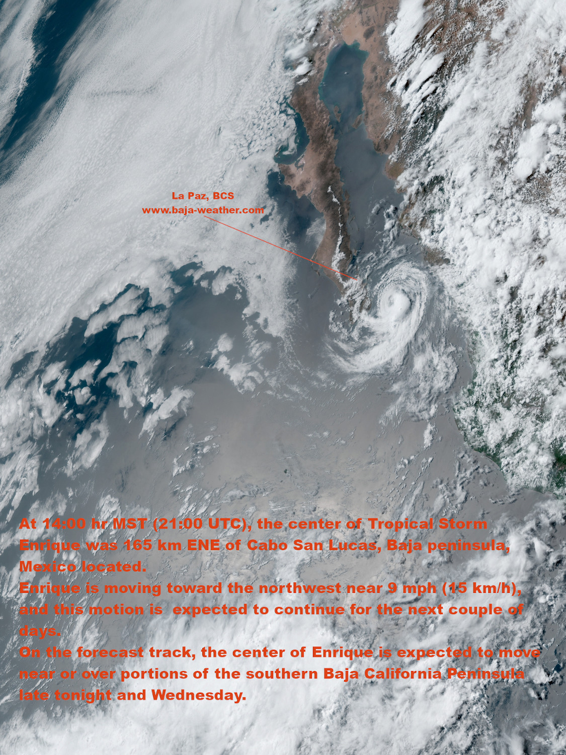
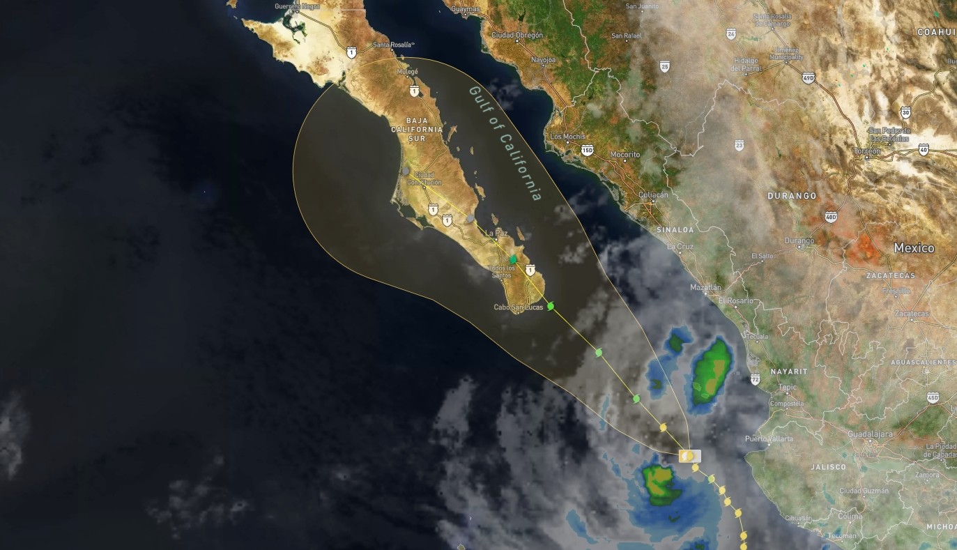
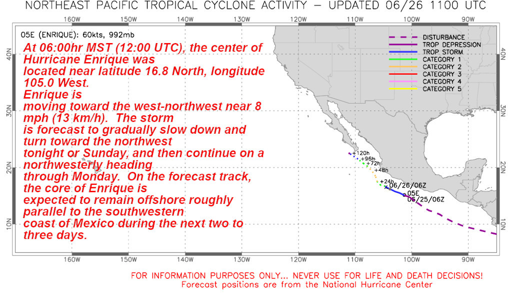
At 14:00 hr MST (21:00 UTC), the center of Tropical Storm Enrique was 165 km ENE of Cabo San Lucas, Baja peninsula, Mexico located.
Enrique is moving toward the northwest near 9 mph (15 km/h), and this motion is expected to continue for the next couple of days.
On the forecast track, the center of Enrique is expected to move near or over portions of the southern Baja California Peninsula late tonight and Wednesday.
https://mastodon.online/@bajaweather
The forecast for Monday 28 June 2021 for La Paz area is: Some clouds this morning will give way to generally sunny skies for the afternoon. High 34C. Winds SW at 15 to 30 km/h.
First low tide at 07:12hr, first high tide at 14:45hr, second low tide at 17:50hr, second high tide at 23:33hr.
Sunrise was at 06:36hr and sunset is at 20:13hr.

At 09:00 MST (La Paz time - 15:00 UTC), the center of Hurricane Enrique was located about 245km (150 mi) S of Cabo Corrientes, Mexico and about 670 km (415 mi) SE of Cabo San Lucas, Baja peninsula, Mexico. Enrique is moving toward the north near 6 mph (9 km/h).
Enrique is expected to parallel the coast of Mexico through tonight. A turn toward the north-northwest and then northwest is expected to begin later
today.
We update as storm developes at https://blog.baja-weather.com/
, the center of Hurricane Enrique was located about 245km (150 mi) S of Cabo Corrientes, Mexico and about 670 km (415 mi) SE of Cabo San Lucas, Baja peninsula, Mexico. Enrique is moving toward the north near 6 mph (9 km/h).
Enrique is expected to parallel the coast of Mexico through tonight. A turn toward the north-northwest and then northwest is expected to begin later
today. That general motion should continue thereafter for a few days.")
Though landfall is currently not predicted, some uncertainty remains in the track and intensity forecast, and significant changes could occur in the coming days.
Hurricane Enrique will likely bring heavy rainfall, strong winds, and rough seas to coastal areas along western Mexico through at least June 30.
https://blog.baja-weather.com/post/655055043973857281/enrique27junea
At 13:00 PM CDT (18:00 UTC), the center of Tropical Storm Dolores was located inland over Mexico near latitude 19.5 North, longitude
103.9 West.
Dolores is moving faster toward the north-northwest near 16 mph (26 km/h), and this general motion is expected to continue through tonight.
On the forecast track, the center of
Dolores will move farther inland across the Mexican states of
Jalisco and Nayarit.
https://blog.baja-weather.com/

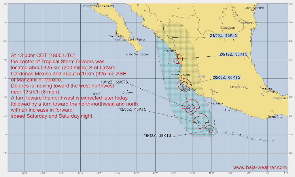
Dolores is moving toward the west-northwest near 13km/h (8 mph).
A turn toward the northwest is expected later today, followed by a turn toward the north-northwest and north with an increase in forward speed Saturday and Saturday night.
On the forecast track, the center of Dolores is expected to cross the coast of west-central
Mexico within the warning area Saturday evening.
https://blog.baja-weather.com/post/654358396580102144/tropicaldolores