
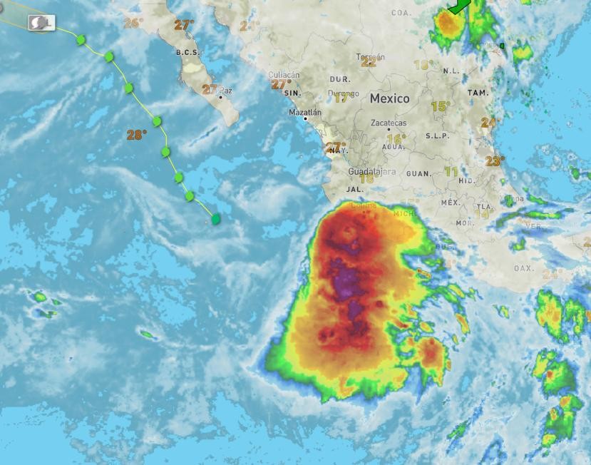
The government of Mexico has issued a Tropical Storm Watch for the southern portion of the Baja California peninsula from Loreto on
the east coast and Puerto San Andresito on the west coast southward.
Tropical storm conditions are possible across the southern
Baja California peninsula by early Wednesday, where a Tropical
Storm Watch has been issued.
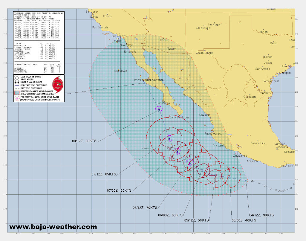
Kay is expected to be a hurricane when it nears the central
portion of the Baja California peninsula later this week.

Continued strengthening is forecast through midweek while it moves northward toward the Baja California peninsula later this week. While the details of the long-range track and intensity forecasts are uncertain, there is increasing risk of wind and rainfall impacts in the Baja California peninsula during the middle and latter parts of the week.
Tropical-storm-force winds extend outward up to 335 km (205 miles) primarily to the northeast of the center.
https://bajaclima.com/Kay5thSep
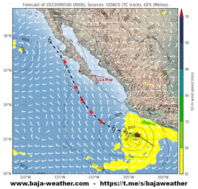
The depression is moving toward the west near 17km/h (10 mph) and a west to west-northwest motion is expected during the next couple of days, followed by a turn to the north.
The depression is expected to remain south of southwestern Mexico during the next couple of days.
Swells generated by the depression expected to reach the southern portion of the Baja California peninsula by Tuesday.
https://ello.co/bajaweather/post/aayfbwb7fmkx1snlblborw
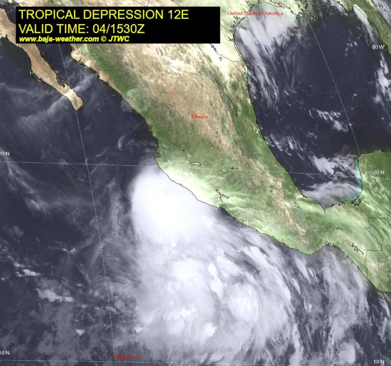
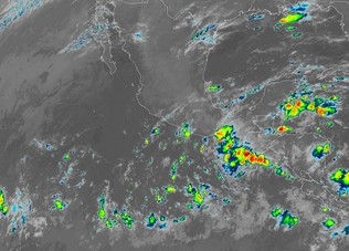
At 10:00hr CDT (15:00 UTC), the center of Tropical Depression Twelve-E was located about 360km (225 mi) SSW of Acapulco Mexico.
Maximum sustained winds are near 35 mph (55 km/h) with higher gusts. Strengthening is forecast, and the depression is expected to become a tropical storm later today. Interests in southwestern Mexico and the Baja California peninsula should closely monitor the depression.
https://blog.baja-weather.com/post/694497256238432256/12e1500cdt
Satellite images indicate that an area of low pressure located about 200 miles south of Acapulco, Mexico, is becoming better defined and showers and thunderstorms continue to show signs of organization.
Moving generally west-northwestward near the coast of Mexico during the next couple of days, bringing heavy rain to portions of that region.
Interests in those locations and the Baja California peninsula should monitor the progress of this disturbance.
https://blog.baja-weather.com/post/694465465189318656/invest93e
Today’s temperature is forecast to be nearly the same as yesterday. Mostly cloudy. Peak temperatures expected 33°C. Winds NNW at 15 to 25 km/h.
The predicted tide times today on Sunday 4. September 2022 for La Paz are: First low tide was at 00:30hr, first high tide is at 13:52hr.
Sunrise is at 07:03hr and sunset is at 19:36.
https://blog.baja-weather.com/post/694464743366443009/4thseptember2022

Indeed it's raining this morning!
For the rest of the day forecast: windy with thunderstorms likely.
Video (just in case you never seen rain fall.... roflmao)
https://t.me/bajaweather/572
Join the Baja Weather Channel >>>
https://t.me/bajaweather

1. September 2022 forecast partial cloudiness early, with scattered showers and thunderstorms during the afternoon. Peak temperatures expected 34°C. Winds E at 15 to 25 km/h. Chance of rain 50%.
First low tide was at 05:39hr, first high tide will be at 12:06hr, second low tide at 19:08hr.
Sunrise is at 07:02hr and sunset is at 19:39hr.

We had several light showers past night and this morning.
For the remainder of the day a 34% chance of precip. / 9.8 mm.
A few isolated thunderstorms developing this afternoon.
Peak temperature expected 32°C. Winds NNE at 5 to 10 mph.
Sunrise was at 07:02hr and sunset is at 19:40hr.
https://blog.baja-weather.com/post/694119532041846784/31august2022

Sunshine and clouds mixed. Peak temperatures expected to reach 40°C, Winds ENE at 10 to 15 km/h. Sunset is at 20:09hr. Stay hydrated, drink plenty of water. Have a marvelous Baja Sur weekend!
https://blog.baja-weather.com/post/690506462482612224/22-25july22

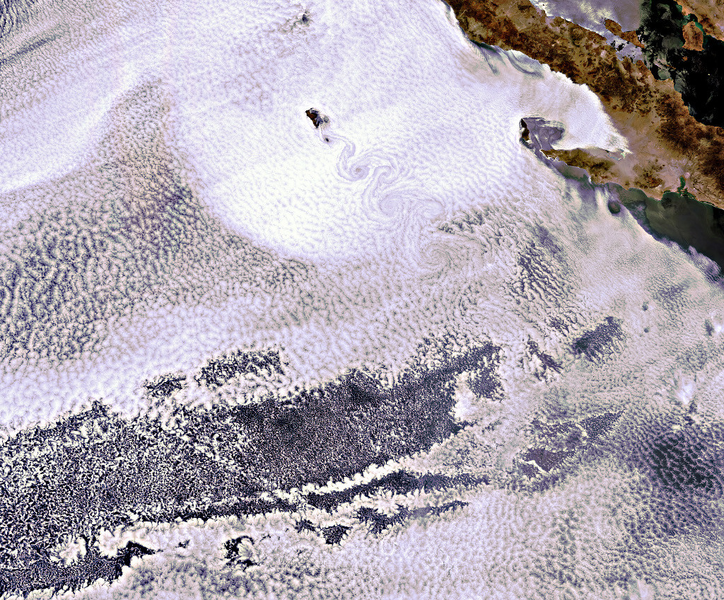
Envisat image showing the volcanic island of Guadalupe peeking through the clouds.
The island lies in the Pacific Ocean around 250 km off the west coast of Mexico's Baja California peninsula.
The swirling clouds to south of the island are the result of a meteorological phenomenon known as a 'von Karman vortex'.
As wind-driven clouds encounter Guadalupe, they flow around the high volcanic outcrop to form the large spinning eddies that can clearly be seen in the image.
https://ello.co/bajaweather
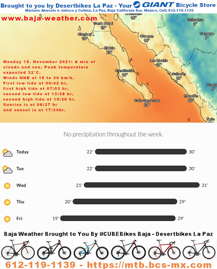
Monday 15. November 2021: A mix of clouds and sun. Peak temperature expected 32°C. Winds NNE at 15 to 30 km/h.
First low tide at 00:42 hr, first high tide at 07:03 hr, second low tide at 13:38 hr, second high tide at 19:36 hr. Sunrise is at 06:37 hr and sunset is at 17:34hr.
https://blog.baja-weather.com/post/667922003007864832/15nov2021
Columbia University’s climate school recently published a global dataset with estimates of both population and temperature. The data analyzed — spanning 1983 to 2016 — and found that exposure to extreme heat has tripled and now affects about a quarter of the world’s population.
https://bajaclima.com/climateheat

Today a mix of clouds and sun. High 33C. Winds N at 10 to 15 km/h.
The National Hurricane Center is issuing advisories on Tropical
Depression Terry, located several hundred miles south of the
southern tip of the Baja California Peninsula, and on Tropical
Depression Sandra, located several hundred miles southwest of the
southern tip of the Baja California Peninsula.
Tropical cyclone formation is not expected during the next 5 days.
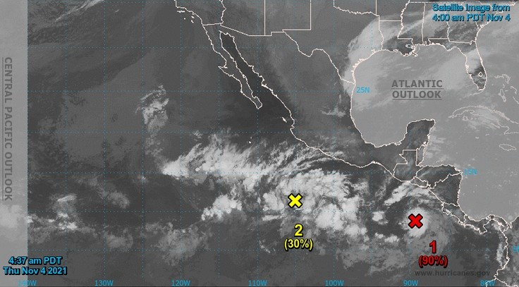
An area of disturbed weather associated with widespread but
disorganized showers and thunderstorms is located several hundred miles southwest of Acapulco, Mexico. Environmental conditions appear conducive for gradual development, and a tropical depression could form later this week or this weekend
Currently there a few clouds, around 19°C in La Paz Fidepaz area, winds SSW at 15 to 25 km/h. Sunset is at 17:42 hr.
Fair skies for trick-or-treaters but it’s maybe be chillier than average later on.
Día de las Brujas is hailed mainly as a children’s festivity in Mexico on October 31.
http://blog.baja-weather.com/

Forecast today on Monday 25 October 2021: Abundant of sunshine, peak temperatures 32°C, winds SW at 15 to 30 km/h. Sunrise was at 07:24hr and sunset is at 18:46hr.
The predicted tide times today are for first high tide at 00:36am, first low tide at 03:49hr, second high tide at 10:46hr, second low tide at 18:17hr.
https://blog.baja-weather.com/post/666023675841134592/25thoct5days

A broad area of disturbed weather located a few hundred miles south of the coasts of Guatemala and El Salvador continues to produce widely scattered showers and thunderstorms.
Environmental conditions are expected to be conducive for gradual development of this system during the next several days, and a tropical depression is likely to form by late this week or this weekend
https://blog.baja-weather.com/post/665560369943789568/disturbance
A faster northeastward
motion is expected later today. On the forecast track, the center
of Pamela will make landfall in west-central Mexico within the
hurricane warning area later this morning and move inland over
western Mexico later today.
At 15:00 MDT (2100 UTC), the center of Tropical Storm Pamela was located by an Air Force Reserve Hurricane Hunter Aircraft about 385 km (240 mi) SW of Mazatlan Mexico and about 220 km (135 mi) SSE of the southern tip of the Baja California peninsula.
On the forecast track, the center
of Pamela will pass well south of the southern tip of the Baja
California peninsula through tonight.
Tropical storm conditions, primarily in gusts, are possible within Baja California del Sur.
