
Monday 19. October 2020, forecast predicts plenty of sunshine, peak temperatures during afternoon at 37°C, winds WNW at 10 to 15 km/h. The rest of the week should be very similar. There is also no hurricane activities expected during at least the coming 48 hours.
https://blog.baja-weather.com/post/632413779074940928/19october2020

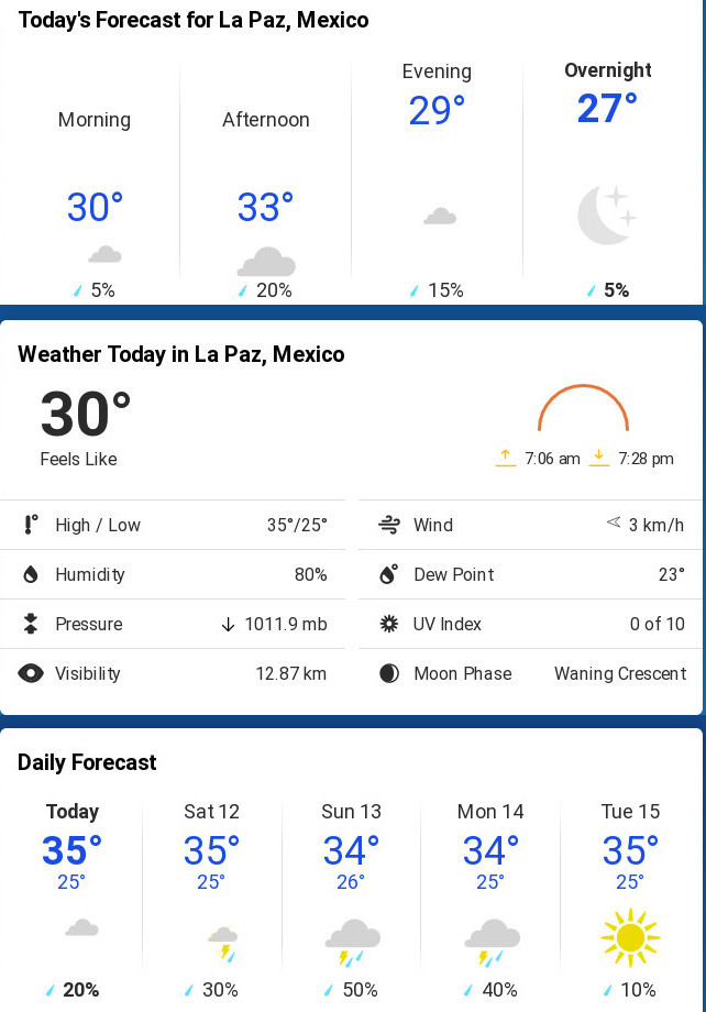
Forecast for Wednesday 14. October 2020 is partly cloudy, peak temperature 34°C, winds SW at 10 to 15 km/h. Sunrise at 07:19hr and sunset 18:56hr.
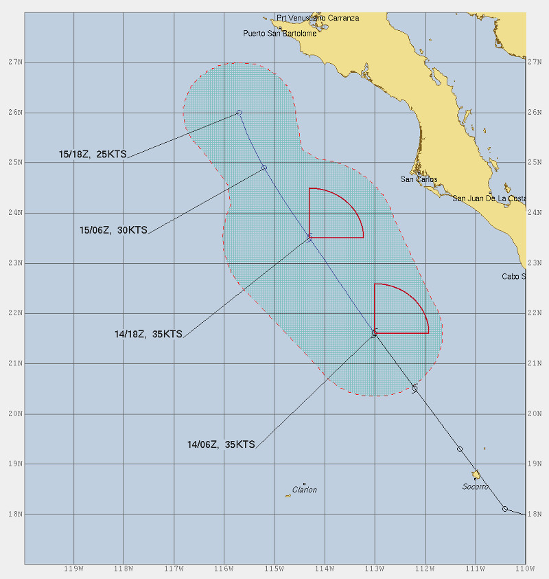
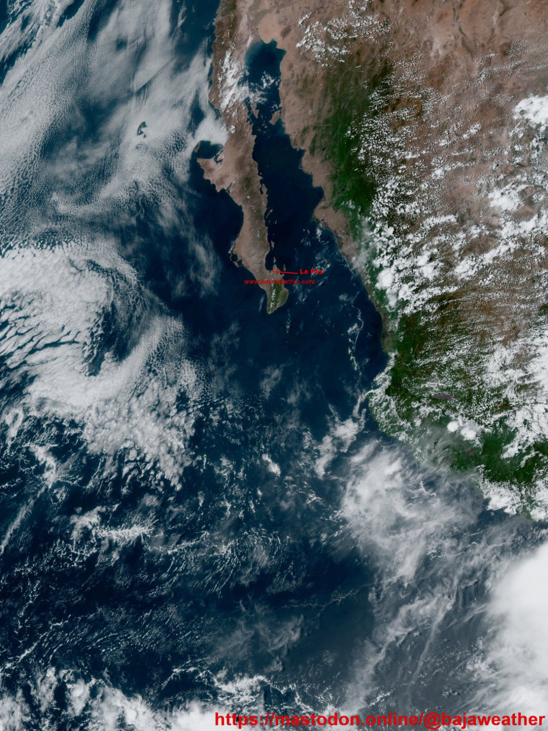
Tropical Storm Norbert maintains its strength for now yet is expected to begin weakening later today. Location is about 360 km WSW of the southern tip of Baja California with maximum sustained winds of 65 km/h (40 mph).
https://blog.baja-weather.com/post/631955269220515840/1410norbert
Tuesday 13. October 2020:
Cloudy with rain ending for the afternoon. Expected peak temperature 31°C.
Winds NE at 15 to 25 km/h.
Chance of rain 80%.

Some rain would not hurt us and we may get some… According to forecast it will be mostly sunny skies this morning which will become overcast during the afternoon, peak temperatures expected about 33°C, winds ESE at 15 to 25 km/h.
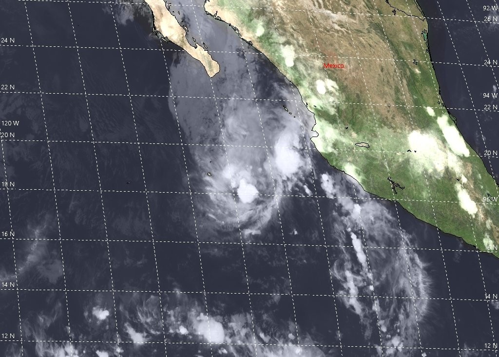
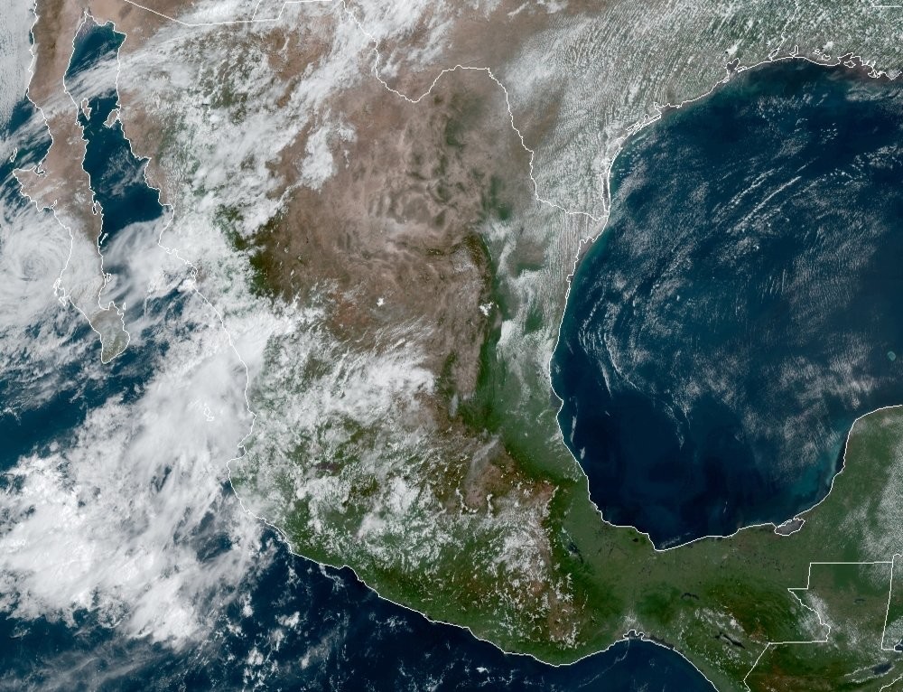
An area of low pressure associated in part with the remnants of Norbert is located a few hundred miles southwest of the southwestern coast of Mexico.
Recent satellite-derived wind data indicate that this system......
https://blog.baja-weather.com/post/631771188683767808/12october2020

Weekly forecast #BajaSur style: there will be weather and it will be good! ;) It’s a more or less some conditions as last week, mid 30′s°C and sunny. Today, Monday 5. October 2020: Sunny, peal temperature 36°C. Winds N at 10 to 15 km/h.
Sunrise was at 07:15 hr and sunset is at 19:05 hr
http://bajaclima.com/5thOct2020

Monday 28. September 2020 - The forecast is for the coming week pretty much similar to last weeks weather in terms of temperature. We looking at mid-30′s during the usual peak all the week.
Sunrise today is 07:13 hr and sunset at 19:12 hr. Plentiful sunshine during the day, peak temperature 36°C, SSW winds shifting to N at 15 to 25 km/h.
Full forecast >>> https://blog.baja-weather.com/post/630503703893442560/28sept2020

US scientists are raising the alarm over the level of ice in the Arctic Ocean, which has dropped to its second-ever lowest level.
This year's melt is second only to 2012, when the ice shrank to 3.4 million square kilometers, according to the National Snow and Ice Data Center, which has been keeping satellite records since 1979.
http://bajaclima.com/IceMelt

Monday, 21. September 2020: Afternoon showers and thunderstorms are forecast. Earlier partial cloudiness with scattered showers and thunderstorms during the afternoon. High 34C. Winds SSE at 10 to 15 km/h. Chance of rain 50%.
https://blog.baja-weather.com/post/629867286992470016/21sept2020

Sea water potential temperature and mass concentration of chlorophyll in sea water

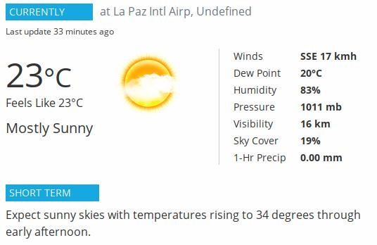
Expect sunny skies with temperatures rising to 34 degrees through early afternoon.
Today, Friday 11. September 2020: Mainly sunny to start, then a few afternoon clouds. High 34°C. Winds NE at 10 to 15 km/h.
Baja Weather Channel blog >>> http://blog.baja-weather.com
Julio degenerates into a trough of low pressure 470 km SW of the southern tip of Baja California peninsula.
Forecast for Monday, 7th September 2020: partly cloudy skies early with heavy thunderstorms developing this afternoon. High temperatures 32°C. Winds SW at 15 to 25 km/h.
Chance of rain 90%.

A small well-defined low pressure system is located about 150 miles south of Acapulco, Mexico. This system is producing a large area of thunderstorms well to the west and northwest of its center and a smaller area of showers near its center.This system is expected to move generally west-northwestward, near or along the southwestern coast of Mexico during the next few days.

How is that for a Friday afternoon?? The weekend can come without any clouds. That was the 4. Sep 2020 - 20:33 UTC pass (14:33 hr La Paz time). It's toasty this afternoon in La Paz measuring 37°C at Fidepaz area of La Paz #BajaWeather #BajaClima #Forecast
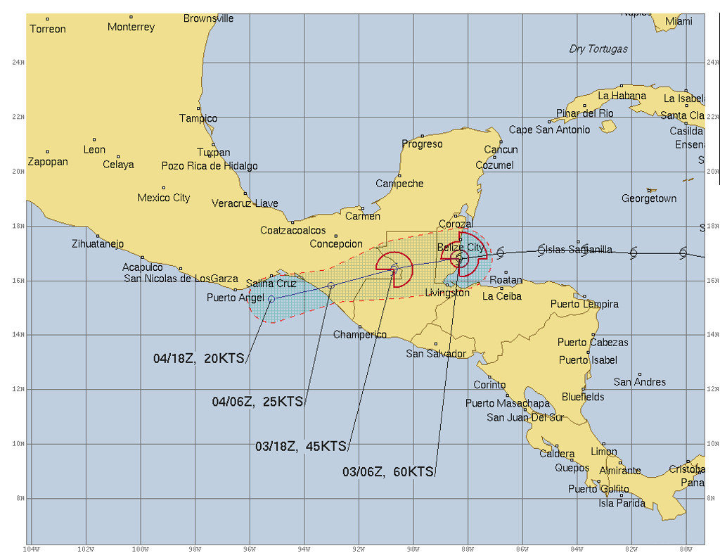
The remnants of Atlantic basin Tropical Storm Nana are expected to emerge over the eastern Pacific waters near the Gulf of Tehuantepec on Friday. Unfavorable upper-level winds are expected to inhibit development through early next week while the system moves generally west-northwestward, near or along the southern coast of Mexico.
In La Paz today, 3.September 2020: Plenty of sunshine. High near 35C. Winds NW at 10 to 15 km/h.
https://blog.baja-weather.com/post/628244684438945792/tropicalnana
La Paz, Wednesday 2. August 2020: Sunshine and clouds mixed.
Peak tem[temperature 34C.
Winds NW at 10 to 15 km/h.
10% precipitation chance....
http://blog.baja-weather.com/
Considerable cloudiness. Low 24C. Winds SW at 15 to 30 km/h.
That's about right if you look at the satellite pass
Today, Monday 31. August 2020 20% chance of rain, mostly cloudy skies.
Peak temperatures expected 33°C.
Winds SW at 15 to 25 km/h.
Ken Graham, director of NOAA's National Hurricane Center in Miami, Fla., reminds us of the hurricane hazards and the importance of having a hurricane plan during this very active 2020 hurricane season
(The 2020 eastern Pacific hurricane season is predicted to produce - with 70% probability for each range - 11-18 named storms, of which 5-10 are expected to become hurricanes, and 1-5 of those are expected to become major hurricanes.
May 21, 2020
https://youtu.be/Bfh1RkrNfGw

Tropical Storm Hernan located northeast of previous estimates could enter the Gulf of California (Sea of Cortez) later this morning. At about 03:00 hr the storm was about 265 km (165 mi) E of the southern tip of Baja California with maximum sustained winds of 65 km/h (40 mph). Hernan is forecast to move over the southern Gulf of California later today and could approach the southeast coast of the Baja California peninsula by late Friday.
 with higher gusts.
Weakening is expected during the next day or so and Hernan is forecast to dissipate on Saturday, if not sooner.
Tropical-storm-force winds extend outward up to 45 miles (75 km) from the center.
On 28-29 August, very heavy rainfall, strong winds and thunderstorms are forecast in Nayarit and Jalisco States, while heavy rainfall is expected over Baja California Sur")