
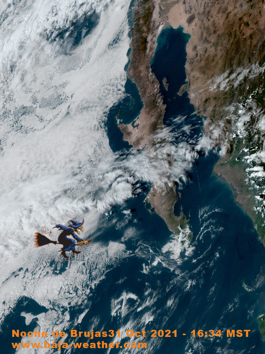
Currently there a few clouds, around 19°C in La Paz Fidepaz area, winds SSW at 15 to 25 km/h. Sunset is at 17:42 hr.
Fair skies for trick-or-treaters but it’s maybe be chillier than average later on.
Día de las Brujas is hailed mainly as a children’s festivity in Mexico on October 31.
http://blog.baja-weather.com/
Forecast today on Monday 25 October 2021: Abundant of sunshine, peak temperatures 32°C, winds SW at 15 to 30 km/h. Sunrise was at 07:24hr and sunset is at 18:46hr.
The predicted tide times today are for first high tide at 00:36am, first low tide at 03:49hr, second high tide at 10:46hr, second low tide at 18:17hr.
https://blog.baja-weather.com/post/666023675841134592/25thoct5days

A broad area of disturbed weather located a few hundred miles south of the coasts of Guatemala and El Salvador continues to produce widely scattered showers and thunderstorms.
Environmental conditions are expected to be conducive for gradual development of this system during the next several days, and a tropical depression is likely to form by late this week or this weekend
https://blog.baja-weather.com/post/665560369943789568/disturbance
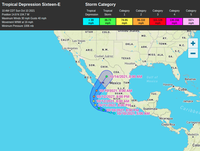
A faster northeastward
motion is expected later today. On the forecast track, the center
of Pamela will make landfall in west-central Mexico within the
hurricane warning area later this morning and move inland over
western Mexico later today.
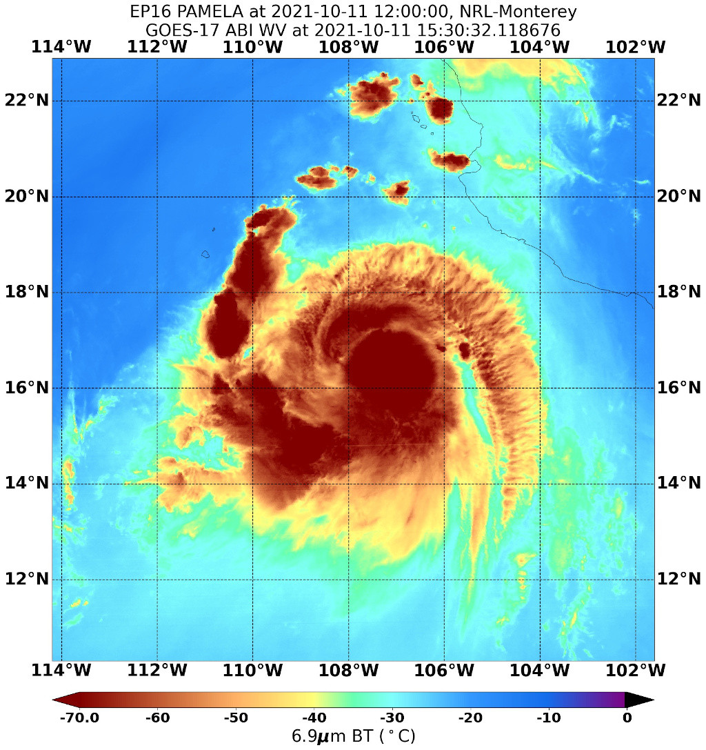
At 15:00 MDT (2100 UTC), the center of Tropical Storm Pamela was located by an Air Force Reserve Hurricane Hunter Aircraft about 385 km (240 mi) SW of Mazatlan Mexico and about 220 km (135 mi) SSE of the southern tip of the Baja California peninsula.
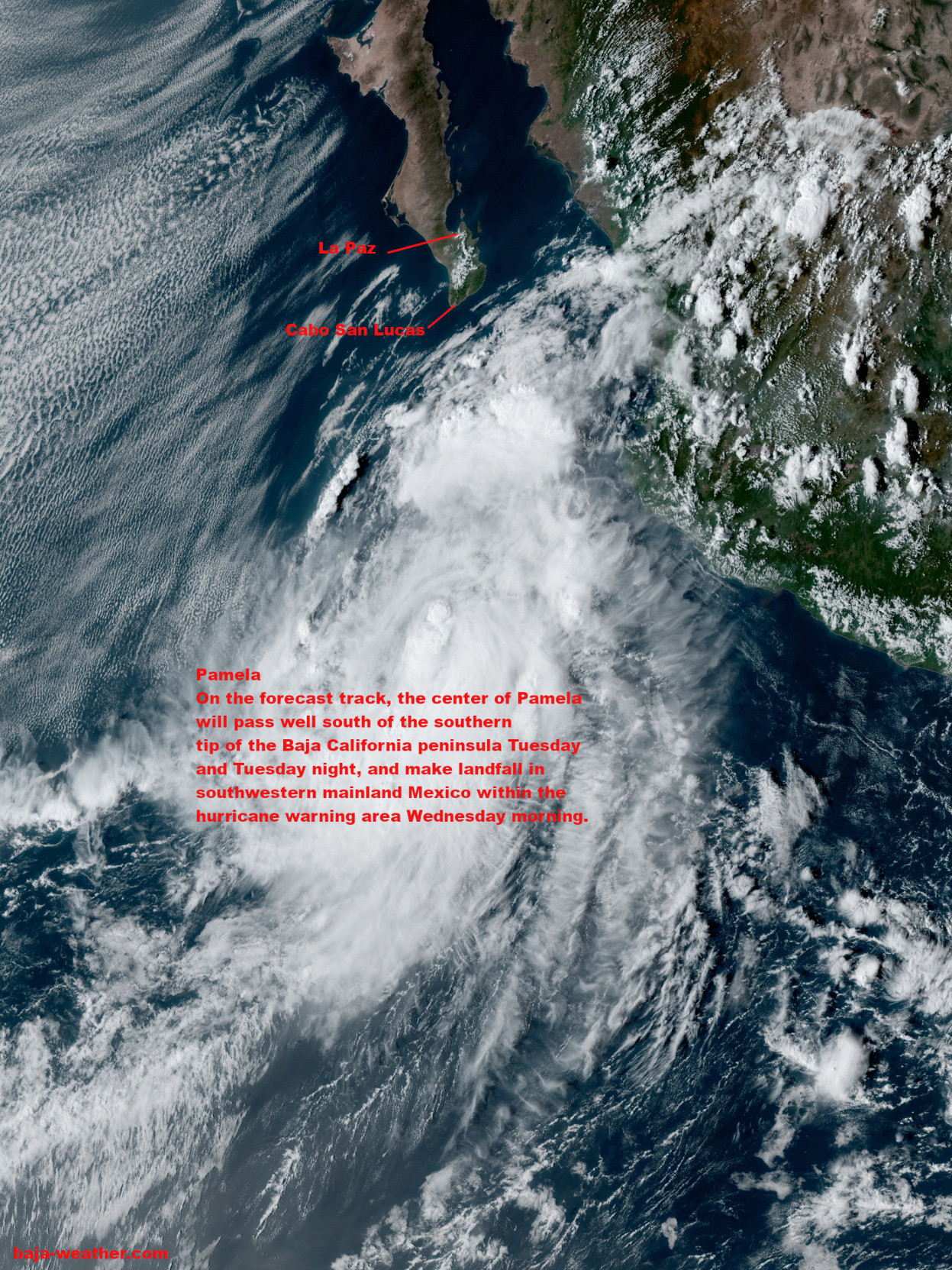
On the forecast track, the center
of Pamela will pass well south of the southern tip of the Baja
California peninsula through tonight.
Tropical storm conditions, primarily in gusts, are possible within Baja California del Sur.

At 06:00 hr MST (12:00 UTC), the center of Hurricane Pamela was located about 455 km (280 mi) SW of Mazatlan Mexico and about 345 km (215 mi) SSE of the southern tip of the Baja California peninsula with maximum sustained winds 130 km/h (80 mph).
https://bajaclima.com/pamela12Oct
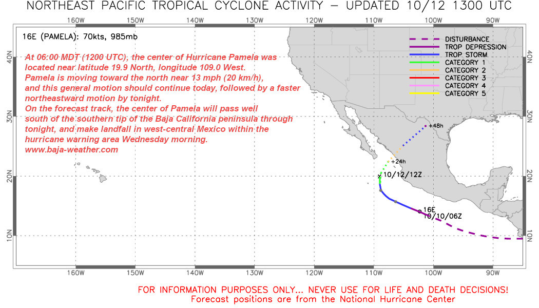
On the forecast track, the center of Pamela will pass well south of the southern tip of the Baja California peninsula Tuesday and Tuesday night, and make landfall in southwestern mainland Mexico within the hurricane warning area Wednesday morning.
Pamela rapidly strengthening!
Hurricane and tropical storm watches issued for portions of southern Baja California Sur peninsula.
At 09:00 hr MDT (15:00 UTC), the center of Tropical Storm Pamela was about 735 km (455 mi) SSW of Mazatlan, Mexico about 705 km (435 mi) SSE of the southern tip of Baja California.
On the forecast track, Pamela will pass south of the southern tip of the Baja California
peninsula Tuesday night or early Wednesday.
Pamela strengthening hurricane watches could be issued tomorrow. 845 km SSE of the southern tip of Baja California.
Interests in southern Baja California del Sur should monitor the progress of Pamela.
While we at southern Baja peninsula are fairly cloud-free them days things are different at the Canary Islands.
Satellite captured this bullseye-shaped cloud over the islands. The eruption of Cumbre Vieja volcano has been strong enough to produce a rising column of emissions that helped form the remarkable pattern in the clouds shown in the image below.
http://bajaclima.com/volcanoerupt

23-foot Saildrone Explorer equipped with a specially designed “hurricane” wing has collected the first video footage of the extreme weather conditions inside a Category 4 hurricane.
https://blog.baja-weather.com/post/663837982639439872/insidehurricane
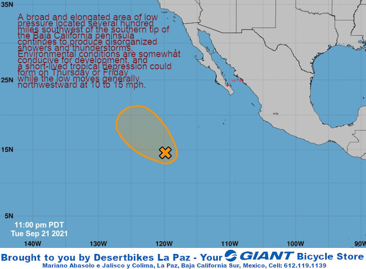
A broad and elongated area of low pressure located several hundred
miles southwest of the southern tip of the Baja California peninsula
continues to produce disorganized showers and thunderstorms.
Environmental conditions are somewhat conducive for development, and
a short-lived tropical depression could form on Thursday or Friday
while the low moves generally northwestward at 10 to 15 mph.
www.baja-weather.com
"We have the tools to achieve this target," UN Secretary-General António Guterres said.
"But we are rapidly running out of time."
https://blog.baja-weather.com/post/662683102863392768/ipccreport
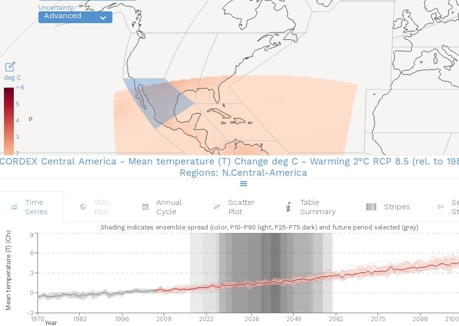
The most up-to-date physical understanding of the climate system and climate change, bringing together the latest advances in climate science, and combining multiple lines of evidence from paleoclimate, observations, process understanding, and global and regional climate simulations.
https://vimeo.com/582875636
Today on Friday 17 September 2021 for La Paz area: Mostly sunny. High 34°C. Winds SW at 10 to 15 km/h.
First low tide was at 02:45hr, first high tide at 09:32hr, second low tide at 14:17hr, second high tide at 20:06hr.
Sunrise is at 07:08hr and sunset is at 19:22hr.
The coming days until Sunday should be very similar - At beginning of coming week may see some rain and thunderstorms.
http://blog.baja-weather.com/

The number of extremely hot days every year when the temperature reaches 50C has doubled since the 1980s, a global analysis has found.
The total number of days above 50C (122F) has increased in each decade since 1980. On average, between 1980 and 2009, temperatures passed 50C about 14 days a year.
The number rose to 26 days a year between 2010 and 2019.
http://www.baja-weather.com/weather-reporting

Sun and clouds mixed. High 33C. Winds WNW at 10 to 15 km/h.
Sunrise was at 07:06hr and sunset is at 19:28hr.

Eyewall of Olaf nearing the southern coast of Baja California Sur, 130 km SE of Cabo San Lucas, Mexico - hurricane warning extended northward to Cabo San Lazaro.
Current situation: Wind buffers (Green: 63-92 km/h, Orange: 93-118 km/h, Red:>118 km/h
On the forecast track, the
center of Olaf will approach the southern coast of the Baja
California peninsula during the next several hours, and then move
very near or over southern Baja California Sur tonight and on
Friday.
http://blog.baja-weather.com/

At 06:00 hr MDT (12:00 UTC), the center of Tropical Storm Olaf was
located about 300 km (185 mi) SE of Cabo San Lucas, Mexico with maximum sustained winds of 110km/h (70 mph).
Olaf is expected to produce total rainfall amounts of 3 to 6 inches with maximum amounts of 10 inches across portions of far southern Baja California Sur today through Friday.
This rainfall may trigger flash flooding and mudslides.
https://blog.baja-weather.com/post/661856163144630272/olaf9sep2021
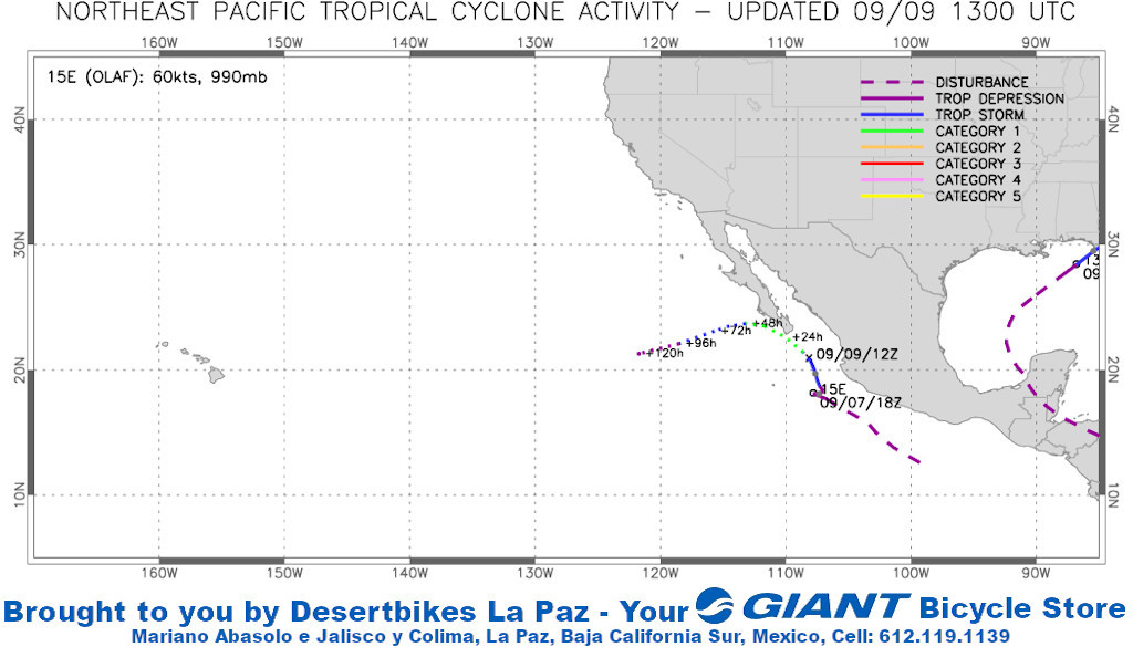
Tropical Storm Olaf formed off Mexico 's Pacific coast on Wednesday and forecasters said the storm could bring rains to the Baja California Sur area, though it wasn't likely to make a direct hit.
The storm was expected to sweep past the tip of the Baja California Peninsula on Thursday and Friday, possibly near hurricane force.
